Murray Irrigation: Making strides in strategic plan

20 January 2024
In line with Murray Irrigation’s strategic objective to provision financially and physically for the intergenerational sustainability of Murray Irrigation’s infrastructure, the company is embarking on a comprehensive asset condition inspection project during 2025 to collect valuable data that will inform the company’s asset management strategy.
To complete these asset inspections, the company has engaged specialist consultants to survey and collect data via aerial photogrammetry and in-channel bathymetric survey across all civil and earthen assets.
Murray Irrigation Head of Water Delivery, Jarryd Pearce, said aerial photogrammetry and in-channel bathymetric surveys are innovative technologies which will allow the company to efficiently collect data on and analyse all its assets.
“Murray Irrigation has a huge footprint, with 2,755KM of channel system and around 3500 bridges and culverts,” Mr Pearce said.
“For the company to send out individual staff to each site to gather this data, it could take years, would incur high costs and lack consistency across how the assets have been captured and inspected.
“By utilising this survey technology, the company will have a consistent set of data captured over a one to two month period that can be stored and analysed to determine the condition of all our assets, which will enable our asset management system to be aligned to best practice.”
Once the survey has been completed, all data will be compiled and digitally assessed over a 12 to 18 month period to provide the company with a comprehensive condition assessment of all civil and earthen assets, including a defects list and silt volumes in channels.
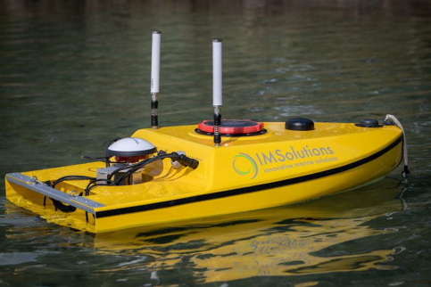
Bathymetric survey uses remote controlled boats equipped with sonar sensors to measure the body of water for depth.
The data will also inform the improvement of the company’s long-term condition monitoring strategy, which could involve imaging technologies such as drone and satellite to monitor weed levels and location.
Murray Irrigation CEO, Ron McCalman, said the quality and quantity of information gathered via these methods will be invaluable to the company.
“This is the first time Murray Irrigation has assessed and benchmarked the entire earthen asset base, which is the largest and potentially highest risk asset due to its potential impact on long-term asset liability,” Mr McCalman said.
“Once all the data is gathered and analysed, the company will have a current and accurate data set to inform the company’s asset management strategy, and be able to accurately project the future cost of maintaining those assets for future generations.
“The combination of photogrammetry and bathymetric survey is the most cost-effective and efficient way to collect and enable analysis of survey data on the entire network.”
Bathymetric survey uses sonar to measure the bottom of a body of water, in this case, the company’s earthen assets such as channels.
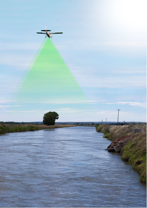
Photogrammetry uses low flying aircraft, at around 1000 feet, to capture high resolution imagery of terrain
(see image at right). This method will primarily capture the company’s civil and earthen assets above the water line such as channels and structures.
“These aircraft will be flying low over the area periodically during February and March,” Mr McCalman said.
“The focus of the survey is on Murray Irrigation assets across the whole footprint, and is not intended to capture any private property. However, if it does so, that survey data will be handled in line with the company’s privacy policy, which can be found on the Murray Irrigation website.
“If you have any concerns about the process, or would like more information on why the company is undertaking this comprehensive asset inspection, please call the customer experience team on 1300 138 265.”
Note:
The green shading in the image (at right) visualises the approximate capture area – there are no green substances being sprayed.
Share this article:

About Us
Projects
Customer Resources
Community
News
Other
Legal
Copyright © 2023 Murray Irrigation Pty Ltd
site by mulcahymarketing.com.au